Golden Software Releases Surfer® 2D and 3D Mapping, Modeling, and Analysis Software
Golden, Colorado, February 15, 2017 (Newswire.com) - Golden Software, the leading developer of affordable scientific graphics software, today announces the release of Surfer version 14, a powerful 2D and 3D mapping, modeling and analysis program designed to facilitate a deeper understanding of geospatial data.
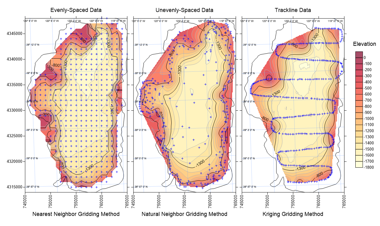
Used by thousands of scientists, engineers, and educators across the globe, Surfer is a leading competitor in data modeling software. Surfer offers thirteen different gridding methods, including Kriging with variograms, to convert regularly or irregularly spaced XYZ data into uniform grids. Display a grid or digital elevation model (DEM) as one of ten fully customizable 2D and 3D grid-based map types: contour, watershed, viewshed, shaded relief, color relief, 1-grid and 2-grid vector, grid value, 3D wireframe, and 3D surface maps. Enhance the display by adding post maps and base maps. Maps generated with Surfer are renowned for their accuracy, clarity, and vibrancy. The latest version of Surfer contains over 60 user-requested new features and 150 enhancements.
The most apparent change is Surfer’s redesigned user interface. The new interface helps the user quickly locate commands needed to complete a task. The ribbon and quick access toolbar can be customized to reflect the needs of each user. Additionally, Surfer’s Map Wizard steps a user through the map creation process, from raw data to the visualized map or model, in as few as three steps.
Surfer’s most popular set of new features are the grid editing options. Users can modify grids and immediately view the changes in their grid-based maps, such as contour maps and 3D surface maps. Contour lines can be edited with the enhanced grid editor which includes the ability to paint Z values across a grid, sculpt the grid’s Z values, smooth the grid in specific regions, push down or pull up Z values in specific regions, assign NoData/Null values to grid nodes, and quickly acquire node values. Users can also create a grid from an existing contour map, project a grid into a different coordinate system, and save grids in STL format for 3D printing.
Additional features include georeference images; download online images, grids, and vectors from OSM, WMS, WCS, or WFS servers; create multiple profiles for multiple surfaces in one-click; create range rings; convert points to polyline and polyline to points; calculate a volume within a polygon; and control more options of the final display including top level legends, adjustments to image brightness, contrast, saturation, and hue, and create page headers and footers.
“Novices and experts alike can use Surfer to transform their data into informative maps and models. The wide variety of import and export formats allow users to seamlessly integrate Surfer into their daily workflows,” said Golden Software CEO Blakelee Mills. “The latest release of Surfer set the bar high and makes Surfer a valuable alternative to other GIS, mapping, and modeling solutions.”
Version 14 also brings more flexible licensing options to better serve companies of all sizes, from individual consultants to worldwide enterprises. Licensing options include single-user, concurrent-use, and enterprise-use licensing as well as university and educational license options.
Surfer v14 operates in a Microsoft® Windows environment with Windows Vista, 7, 8 (excluding RT), or 10. Surfer pricing information is available online. Discounted upgrade pricing from previous versions of Surfer is available. Surfer includes free updates and free technical support. Full online documentation is included. To download a free Surfer trial or place an order, visit www.GoldenSoftware.com.
About Golden Software:
Founded in 1983, Golden Software is a leading developer of affordable scientific graphics software. Its customer base includes over 100,000 users involved in oil and gas exploration, mining, geosciences, engineering, business, education, and government in 186 countries and territories. Golden Software offers seven products: Surfer® for gridding, contouring and 3D surface mapping; Voxler® for 3D data visualization; Grapher™ for 2D and 3D graphing; Strater® for well log, borehole and cross section plotting; MapViewer™ for thematic mapping and spatial analysis; Didger® for digitizing and coordinate conversion; and Raster Tools, an Esri® ArcMap add-in for interpolating raster datasets. For additional information, visit www.GoldenSoftware.com or call 303-279-1021.
Source: Golden Software, LLC
Related Media